The following is the section of the Plan that deals directly with Whiskey Island.
Table of Contents
A. Boundaries
B. Description of the Whiskey Island I Action Area
C. Objectives of the Plan
D. Action Area Development Plan
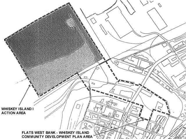
Exhibit 2: Whiskey Island I Action Area map
A. BOUNDARIES
The approximately eighty (80) acre WHISKEY ISLAND I ACTION AREA incorporates roughly the eastern one-quarter of Whiskey Island, north of the Conrail railroad lines, up to and including the former United States Coast Guard Station and water surface north of Whiskey Island. The WHISKEY ISLAND I ACTION AREA is hereby designated as an Action Area for acquisition, clearance, redevelopment, or rehabilitation as herein provided.
B. DESCRIPTION OF THE WHISKEY ISLAND I ACTION AREA
Primary land uses in the WHISKEY ISLAND I ACTION AREA are underutilized open land, railroad lines and rail facilities, and the vacant U.S. Coast Guard Station. The Coast Guard Station is detrimental to the public health, safety, arid welfare by reason of age, dilapidation, faulty arrangement, and lack of ventilation and sanitary facilities and by reason of failure to conform in one or more respects to the provisions of the Codified Ordinances relating to building, housing, and sanitation. The Action Area has a defective and inadequate street layout; a faulty lot layout in relation to adequacy, accessibility, and usefulness; unsanitary and unsafe conditions; detrioration of site improvements; and conditions which endanger life or property by reason of fire or other causes. This area is extensively blighted.
In the vicinity of the Action Area are important water-related industrial, shipping, and entertainment uses that should be carefully considered as design influences to prevent the recurrence and spread of blight. The design of new improvements in the Action Area must take into consideration its relationship to Port Authority property, the Old River Road entertainment area and West Bank industrial, commercial, entertainment and recreation uses.
A number of planning considerations and objectives are relevant to the kind of development which will best prevent the recurrence of blight within the Action Area. These include the following:
D. ACTION AREA REDEVELOPMENT PLAN
1. REDEVELOPMENT PROPOSAL
The City has been presented with a satisfactory contractual commitment from a Developer to redevelop the Action Area with a mixed use development including marinas, retail, restaurant, off-street parking, public open space, and related uses.
2. LAND USE CONTROLS
The renewal, redevelopment, and use of property constituting the WHISKEY ISLAND I ACTION AREA shall be made subject to the regulations and controls specified in this section in order to achieve the objectives of this Community Development Plan.
a. Permitted Land Uses
The following land uses shall be permitted in the WHISKEY ISLAND I ACTION AREA in buildings rehabilitated or constructed and on land improved after the date of original approval of this Community Development Plan by City Council:
(1) Retail, restricted to uses appropriate to serve the needs of users of a public marina, including sale of boating and fishing equipment and supplies, motorboat fuel and food and beverage carryout stores;
(2) Restaurants, cafes, catering services or night clubs;
(3) Public marinas including, on the land portion of the Action Area, enclosed boat storage facilities and public boat ramps.
(4) Public areas and walkways, including landscaped areas allowing free public pedestrian access to the riverfront and lakefront, not to be limited to customers of the above facilities.
(5) Administrative offices related to the above uses;
(6) Parking areas that shall be free to the public during regular business hours.
b. Coast Guard Station Building Requirements
The following building requirements shall be applicable in the WHISKEY ISLAND I ACTION AREA to the rehabilitation of the former U.S. Coast Guard Station:
(1) Rehabilitation Standard
The adaptive reuse of the building shall be accomplished in accordance with the U.S. Secretary of the Interior's Standards for Historic Rehabilitation and shall receive final approval from the Ohio Office of Historic Preservation.
(2) Minimum Size
The rehabilitated former United States Coast Guard Station shall provide, at minimum, twenty-five thousand (25,000) square feet of usable space.
c. Building Requirements for Boat Rack Storage Building
The following building requirements shall be applicable in the WHISKEY ISLAND I ACTION AREA to the new construction of a Boat Rack Storage Building:
(1) Minimum Size
The building shall provide at minimum, forty thousand (40,000) square feet of usable space.
(2) Location
The building shall be located, at minimum, one thousand two hundred (l,200) feet to the west of the Cuyahoga River Channel.
3. ACCESSORY OFF-STREET PARKING
Accessory off-street parking shall be provided within the Action Area such that a minimum of one thousand five hundred (1,500) automobile parking spaces and three hundred (300) boat trailer parking spaces are developed. Accessory off-street parking shall be constructed and maintained in accordance with all applicable City standards and requirements.
4. VEHICULAR TRAFFIC
Vehicular circulation within the Action Area shall be designed to minimize both traffic congestion and pedestrian/vehicular conflicts. A Circulation Plan shall be submitted by the Redeveloper to the City Planning Commission for approval. The Circulation Plan shall identify the vehicular and pedestrian paths both to and within the Action Area.
5. MARINA REQUIREMENTS
The following requirements shall be applicable in the WHISKEY ISLAND I ACTION AREA:
a. Maximum Size
All marinas in total shall contain not more than six hundred (600) boat slips for small motorboats or sail boats.
b. Mooring Requirements
No mooring of boats shall be permitted on the easterly side of former U.S. Coast Guard Station within the Cuyahoga River Channel. Further, any marina design within the WHISKEY ISLAND 1 ACTION AREA shall be subject to the regulations, standards and approval of the United States Coast Guard, the United States Army Corps of Engineers, and the City of Cleveland, Department of Port Control.
6. PEDESTRIAN REQUIREMENT
The Redeveloper shall construct a boardwalk or pier to provide continuous pedestrian access to the water from parking areas to the site of the former U.S. Coast Guard Station.
7. LANDSCAPING REQUIREMENTS
A Landscaping Plan shall be submitted by the Developer to the City Planning Commission for approval. The Landscaping Plan shall describe the number and location of shrubs, earth mounds, plantings, and trees.
The Redeveloper shall adhere to the following general landscaping provisions:
a. All parking areas shall be bordered by trees; all ends of parking stall rows shall be landscaped with curbed tree and shrubbery planting areas.
b. All parking areas shall be paved, properly drained, lighted, and have striped spaces.
c. Trees and other plantings shall be used liberally in open areas and parking areas to soften the development's appearance.